
By Benj Edwards for Fast Company
WITH BACKING FROM ATARI’S COFOUNDER, AN ENGINEER-NAVIGATOR BROUGHT HIGH-TECH DRIVING DIRECTIONS TO CARS—DURING THE REAGAN ADMINISTRATION.
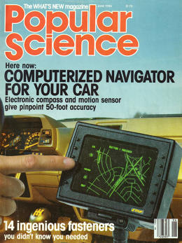
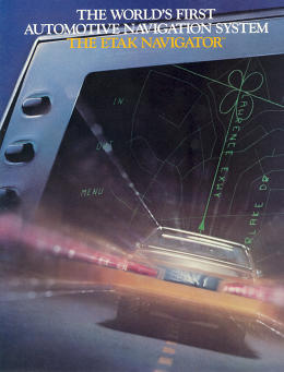
Thirty years ago, a company called Etak released the first commercially available computerized navigation system for automobiles. Spearheaded by an engineer named Stan Honey and bankrolled by Nolan Bushnell, the cofounder of Atari, the company’s Navigator was so far ahead of its time that the phrase “ahead of its time” seems like an understatement.
To appreciate just how amazing the concept of car navigation was in 1985, you need to recall that the Global Positioning System—the constellation of satellites operated by the U.S. government—didn’t come fully online until a decade later, in 1995. Even then, the feds crippled GPS to be no more accurate than within 100 meters to ensure it wouldn’t help bad guys aim guided missiles. In 2000, that restriction was lifted, allowing a new era of consumer GPS navigational gadgets to flourish.
Etak beat modern GPS systems to market by a decade and a half. It was so early that its inventors had to digitize their own maps and figure out how to get them into an automobile in an era before solid-state mass storage, optical discs, or wireless Internet was available to do the job. (The solution: special tape cassettes.)
Everything about Etak’s Navigator had to be conceived from scratch. And it worked.
The Navigator wasn’t a big seller, especially by 2015 standards. But neither was it a dead end. To build it, Etak had to devise technologies and collect data that are still in use today by some of the most familiar navigation apps and devices on the planet. This is the little-known story of how it came to be.
IT STARTED ON A YACHT
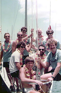
The idea that became Etak began on the high seas. Bushnell had hired Honey to navigate his racing yacht Charley through the 1983 Transpacific Yacht Race, a prestigious sailing event that spanned 2,225 nautical miles of open ocean from Los Angeles to Honolulu.
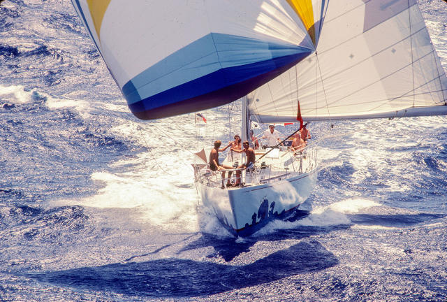
One morning, around 4 a.m., the two men happened to be on night watch together. As the rest of the crew slept, they worked to get a fix on their location using a satellite orbiting the earth. It passed overhead once every 12 hours; through measuring Doppler shifts in radio waves, specialized equipment could determine a vessel’s latitude and longitude. However, its passage was only frequent enough to give the navigator a starting point to work from.
To keep track of Charley‘s whereabouts between those twice-daily satellite pings, Honey needed to calculate position based on the ancient techniques of celestial navigation, using a sextant, and of dead reckoning, which involves keeping track of distance and direction traveled and as compared to a previously known location.
For this particular race, Honey had a little help from modern technology. Bushnell had commissioned Honey—who spent his non-sailing days as an engineer at legendary Silicon Valley research institute SRI International—to construct one of the world’s first computer-based marine navigation systems for Charley. The computer, codesigned by SRI colleague Ken Milnes, aided the process of collecting data from sensors on the ship and making course calculations.
Even with the computer, marine navigation in the pre-GPS era was never easy. The difficulty of plotting a course at sea got the two men talking. “We joked that it would be really easy if we didn’t have all of this squishy stuff under us,” recalls Bushnell.
And so during that watch, Bushnell and Honey began brainstorming about a computer-based navigation system for use on land. A navigation system for automobiles could, Honey surmised, operate based on dead reckoning and comparing one’s current location to known points on a map, a technique known as map matching. It wouldn’t need satellites at all, just a digital good map, a good compass, and some sensors. Then it could display the result on an electronic screen.
“I basically said, ‘Yeah, let’s do that and I’ll fund it,'” says Bushnell. And that was how it started.”
At the end of the race, Charley received first-to-finish honors, with Honey’s computerized navigation assistance system playing a notable part in the victory. After nine days without much sleep, Bushnell collapsed in his room and slept for 15 hours straight. Yet as Honey recovered from the voyage, he began to turn over ideas for a never-before-produced car navigation system in his head. He had already charted a new course—only this time, the race would be on land.
THE NAVIGATOR AND THE ENTREPRENEUR
Born in Pasadena, California, in 1955, Stan Honey was immersed in sailing culture from an early age. “I grew up sailing dinghies and my family’s boat from when I was probably six,” he recalls. “I developed an interest in navigation because my father had been a navigator and my godfather was a navigator in the war.”
While studying at Stanford, Honey joined a co-op program at SRI, researching precision navigation and remote sensing technology for military and government use. On the side, he served as navigator for several marine sailing races; by the time Bushnell tapped him to be his navigator for the 1983 Transpac, he had already navigated a Transpac-winning vessel, Drifter, in 1979.
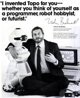
As navigation was to Honey, entrepreneurship was to Bushnell, who sold Atari to Warner Communications in 1976. In 1983, he was 40 years old, investing in startups, and hopping from one idea to the next faster than most could keep track. His company, Catalyst Technologies, was one of the world’s first incubators. Among the companies he founded or fostered in the 1980s were ByVideo (electronic shopping, 1983), personal robots (Androbot, 1983), and Furby-like interactive toys (Axlon, 1985). None of Bushnell’s follow-ups were remotely as successful as Atari—in fact, they tended to get a lot of attention, and then crash and burn—but he had an uncanny ability to identify big ideas in bleeding-edge form.
It was into Catalyst’s offices that Honey walked one day in late 1983. He began discussions with Bushnell on how their proposed automobile navigation company should come to fruition. The pair settled on a plan that was typical with Bushnell’s other startup investments: Honey’s new company would take an initial seed round of capital, and its offices would be located within the Catalyst facility until it was ready to move out on its own.
With money in hand and encouragement from Bushnell and fellow Atari alumnus (and Pong designer) Alan Alcorn—a regular at Catalyst—Honey began to build a business. He started by inviting Ken Milnes and another SRI colleague, Alan Phillips, to join him in the venture. Within a few months, six other SRI veterans came aboard, including an engineer named Walter Zavoli.
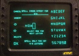
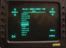
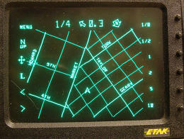
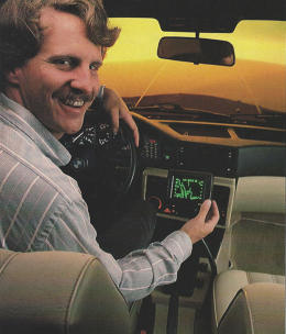
The newly formed crew defined the goal at hand: to produce a navigation system that could be installed as an aftermarket accessory in any car. The device would tell the driver where he or she was at all times via a CRT display on the dashboard, and it would also plot the location of a selected destination and keep track of the directions to that destination until the driver got there.
As it turns out, developing the hardware for this device ended up being the straightforward part. Beyond compasses, computers, and displays, there were deep mathematical problems to be solved regarding data, algorithms, and maps. In fact, Honey wondered: Where would they get the map data, and moreover, how would their device store it and quickly access it once they had it?
“I read all the papers I could find on the topic,” Honey recalls. Soon it became clear that the team needed someone who understood digital mapping and had the skills in topological mathematics that were needed to store digital map data efficiently. “I discovered that there were really only two guys who could do that,” says Honey. “One of them I just happened to know personally through a completely unrelated family connection.” That was Marvin White, who worked for the U.S. Census Bureau.
Since its formation, the Census Bureau had always needed precise maps for census taking. In the 1960s, the Bureau’s statisticians decided that the newly emerging field of computers could help make their maps more accurate and improve route planning for both mailing and door-to-door enumerating. In the process, they invented an efficient way of digitally storing map data as a system of points, vectors, and polygons called DIME (Dual Independent Map Encoding). White moved from Washington, D.C., to join Honey’s fledgling company, and began to apply his mathematical knowledge to the creation of mapping algorithms for the world’s first computerized auto navigation system.
Soon, Honey’s team also began to assemble groups of digitizers—employees who would take publicly available map data and enter it into a computer. (Naturally, they started with data for the San Francisco Bay Area.) His engineers developed a proprietary way of speeding up the process by crafting software tools that corrected for distortions in scans of aerial photography, another key innovation. With those tools, they could digitize maps much faster than previous methods, which typically involved manual, point-by-point entry of landmarks and roads.
The team needed a rugged way of storing the map data for the navigation computer to use. The storage medium had to be resistant to shock and vibrations, and able to withstand the heat of a closed car on a hot day. The team focused on a specialized cassette-tape drive, which proved far more rugged and less expensive than a floppy-disk mechanism.
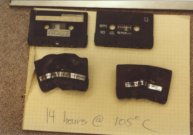
Each tape could hold 3.5MB of data, which was quite a bit for low-cost removable computer storage at the time. Even so, a map of the Bay Area still stretched across six tapes. That made tape switching a significant issue because, as it turns out, regular cassette tapes—like those used to store data with home computers at the time—had a tendency to melt. “The automotive environment is difficult for electronics,” recalls Walt Zavoli, who was then the director of R&D. “Because customers would be switching map cassettes as they drove, we knew cassettes would wind up sitting on top of the dash, baking in the summer sun.”
So they tested various materials for cassette shells to see what could tolerate the heat. They settled on a polycarbonate shell that could withstand sustained exposure to temperatures up to 105 degrees Celsius.
And what of the computer that would read that data—the heart and brains of the system? For that, the team relied on mostly off-the-shelf components. The computer, which fit in a shoebox-sized extruded aluminum chassis, was about as powerful as a standard IBM-compatible desktop PC of the day—which is to say, not very, especially considering the multitude of computing tasks it had to accomplish in real time.
For a display, the engineers selected a vector-based CRT, a display tube capable of only drawing lines with a single electron gun, similar to those used in oscilloscopes—as well as Atari games such as Asteroids. They chose a vector unit because a high-enough resolution bitmapped display would have been prohibitively expensive in 1984. The vector display was crisp and legible. It was also bright, which aided with readability during daylight hours.
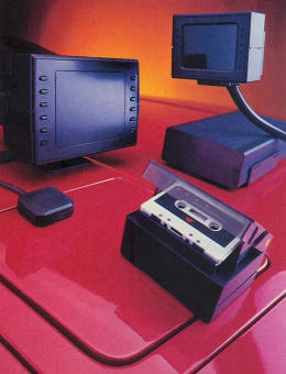
Since aid from satellites was out of the question, the computer would have to rely on sensors to keep track of the world around it. To do so, Honey’s engineers designed a custom electronic compass, which would be mounted to the rear windshield, and a set of wheel sensors affixed to a car’s non-driven wheels to determine speed, distance traveled, and turn direction.
While experimenting with a map on the vector display, the team found that a fixed-map viewpoint with a roving on-screen car cursor proved unintuitive while driving. So they switched to a driver-centric viewpoint that turned and moved around a fixed point in the middle of the screen representing a car. We take this for granted in auto navigation systems today, but the team behind the Navigator invented this display method.
That “heading-up” technique reminded Honey of ancient Polynesian navigation concepts that he had read about during his studies of navigation in previous years. The ancient mariners of that region navigated the seas by relying on a series of environmental cues, such as the positions of islands around them, combined with a mental perception of themselves in the center of the conceptual navigational space in their heads. With that in mind, Honey decided to call his new company Etak, which is a Polynesian term for moving navigational reference points.
When Etak’s navigation system was finally put together, it worked so well that those who tried it felt they were witnessing some manner of technological trickery. “It was hard for people to believe that it worked,” recalls Honey. “It’s a funny thing to say, but it was hard to sell, because people had no expectation that there was something like that that was available.”
Today, a smartphone can provide driving directions, thanks to a GPS receiver capable of talking to a network of satellites and maps downloaded wirelessly across the Internet. Honey’s invention needed no satellites and no Internet: just a compass, some sensors, on-board map data, and some very clever algorithms. And it worked like magic. So well, in fact, that modern navigation software still uses some of Etak’s map-matching techniques to improve the accuracy of the car’s on-screen location while driving. Otherwise, it might look like you were driving a few yards beside the street.
“What we were doing was basically taking advantage of the fact that drivers tend to use roads,” says Honey. Etak’s algorithms would match the travel path of your car with known road shapes in its database, then visually place the on-screen car cursor in that position on the digital road map. While using the Navigator, the system continuously ironed out accumulated errors over time by comparing actual distances driven and turns made with road shapes on the map. Honey calls the technique “augmented dead reckoning.”
That means driving through a long stretch of straight highway could begin to trip up Etak’s system, since there were no turns and no distinct roads for the computer to algorithmically seize upon. If that happened, the driver could manually reposition the car cursor onto a location on the map using controls on the display.
Etak’s engineers decided it would be too dangerous and distracting to operate the display’s controls in a moving vehicle. So they disabled destination entry or car repositioning while the car was in motion—decades before the rest of the world began to worry about the dangers of distracted driving.
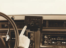
Here’s a look at how the Etak user interface—which utilized ATM-like buttons along the side of the screen—operated.
ETAK INTERFACE | PHOTOS: WALT ZAVOLI | CLICK TO EXPAND

A VISION THAT WORKED
Development on Etak’s navigation system continued throughout 1984. During testing, Etak boiled the system down into two variants: the 700, which shipped with a 7-inch screen, and the 450, which shipped with a 4.5-inch screen. They called the product the Etak Navigator, and began to show it to the press in late 1984.
1984 proved a difficult year for Etak’s primary investor, Nolan Bushnell. Due to poor management and the video-game market crash, his once-promising Pizza Time Theater business filed for bankruptcy, forcing a sale of its subsidiary, Sente Technologies—a firm prized by Bushnell as a potential source of video-game innovation in his post-Atari career. (Pizza Time hung on, and, after a merger with a competitor, is still with us today as Chuck E. Cheese.) Another Bushnell firm, Androbot, which overpromised a world of intelligent home entertainment and service robots in the early 1980s, also failed spectacularly and invited chiding I-told-you-so’s from the press.
Etak was a bright spot among Bushnell’s startups, and without the vision that led him to fund Honey’s idea, the company might never have happened. And as usual, Bushnell had a prescient appreciation for where consumer technology might eventually go. “Let’s say you’re in your car, and you want to go to dinner,” he said in an interview for a 1984 Inc.magazine feature. “You’ve got this box on the dash. You punch in ‘Japanese,’ then ‘cheap,’ then ‘good sushi.’ The box takes over and guides you to a place.” The author of the article retorted, “Where Etak will guide Nolan Bushnell seems these days a little beside the point.” But the feature that Bushnell was enthused about—Etak hoped to add business information to its data—did pretty much what Yelp’s smartphone app does today.
In contrast to other post-Atari Bushnell startups—which tended to sound visionary, generate enthusiasm, and then collapse—Etak succeeded and even thrived. Honey staffed it with extremely competent and technically skilled people; Bushnell provided financial resources, then mostly stepped back rather than being involved in day-to-day management. “It was really the Stan Honey show,” says Bushnell today. “I was a bit player at best.”
Former Etak engineer Walter Zavoli has particular praise for Honey’s confident, steady, but not-overpowering managerial talents, comparing them to Honey’s role as navigator on a yacht: “Most of Stan’s professional sailing involved navigating the sailboat, not being its captain. The navigator is responsible for offering the captain a strategic plan regarding what path to follow.” Accordingly, Honey quickly concentrated on engineering, turning over the company’s presidency to George Bremser.
HITTING THE ROAD
The Etak Navigator first shipped around July 1985, with the 450 model retailing for $1,395 (about $3,083 when adjusted to 2015 dollars) and the 700 selling for $1,595. Map cassettes cost about $35 each. Only the Bay Area of California was initially available, followed by rollouts for other major metropolitan regions. Local car stereo and cellular telephone dealers installed and calibrated the system, a process that took a couple of hours.
The Navigator was so ahead of the game that it was not only the first commercial car-navigation system available, but the only one at all for two years. Etak did it, and did it so well, that most of the succeeding navigation devices that hit the market throughout the end of that decade licensed the company’s patents, its map data, or its hardware.
And that led the way to Etak’s real opportunity. Consumer electronics was a hard business. For most folks in the 1980s, it was very difficult to justify spending almost $2,000 to put a digital map in your car. But the price was less of a barrier for companies with commercial trucking fleets, and Etak’s map data appealed to firms like Coca-Cola and UPS, which used it in their dispatch centers to plan optimal delivery routes.
Honey estimates that Etak sold between 2,000 to 5,000 units, with the 4.5-inch model appealing more to drivers of private passenger vehicles and the 7-inch model proving most popular with commercial trucking applications. But as sales waned, Etak successfully pivoted away from hardware in the late 1980s. Working with an army of hundreds of mappers around the world, it digitized most of the Earth’s roads and landmarks. The data they collected was so fundamental and accurate that it’s still in use, including in Apple’s Maps app.
Etak realized that digital mapping was not just an exercise in codifying public spaces and residential addresses. It could provide optimal routes to commercial places as well, and that interested Australian media mogul Rupert Murdoch. With this in mind, his firm, News Corporation, bought Etak in 1989 for around $25 million. Soon after, Stan Honey became VP of technology for News Corp.
Bushnell was pleased with the outcome, noting that Etak was one of his more successful investments. And it proved to be a positive mark on his long resume of sometimes ill-fated, but always imaginative, entrepreneurial efforts.
Etak changed hands again several times over the years, growing in sale price each time as the value of its map data and fundamental navigational patents became more and more apparent. When Sony acquired the company in 1996, the price was around $100 million. Etak eventually became a part of TomTom, ensuring that its map data, some of which was first digitized back during the Navigator’s development in 1984, would live on to this day.
Honey, Milnes, and a few of his Etak colleagues later moved on to other tangentially navigational-related ventures, such as leading the team that created the glowing video halo around a hockey puck for televised NHL games (by tracking the position of the hockey puck in the rink), and creating the digital first-down line for NFL TV broadcasts. None of those would have happened without Honey’s love of sailing, and his thirst to thoroughly understand and master the art of navigation. Today, at 60, he continues to navigate for winning sailboat racing crews around the world.
Meanwhile, the notion that a mobile device can help you get where you’re going—so mind-bending in 1985 that people could barely comprehend it—is now so ingrained in everyday life that we no longer think of it as remarkable. But it is. And the fact that we all get lost a lot less often than we once did is Etak’s lasting legacy.